

Key takeaway: GPS dog collars can calculate location in many outdoor places with sky view, but roughly 30% of U.S. land area has no cellular coverage, which means most collars can't send that location to your phone. Satellite-ready backup built into the collar itself (not a separate device) is the stronger design path for tracking, geofencing, and health alerts when you leave cell service.
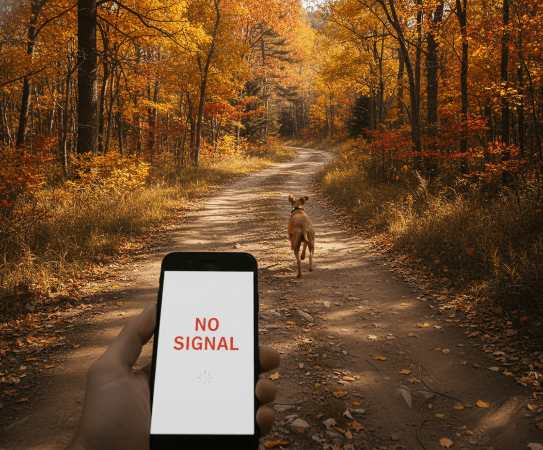
It is 4:30 PM on a Saturday in October. You are two miles into a trail in the Appalachian foothills with your dog off-leash, something you have done dozens of times before. She knows the trail. You know the trail. This is routine.
Then a deer bolts across the path.
Your dog is gone before you can react. She tears into the underbrush, over a ridge, and out of sight in seconds. You call her name. Nothing. You whistle. Nothing. You pull out your phone to check her GPS collar.
No signal.
Not your phone. The collar. The $300 smart collar you bought specifically for moments like this cannot tell you where your dog is because there is no cellular tower within range. The collar knows exactly where she is. It just cannot tell you.
You are standing in a dead zone, holding a phone that says "Location unavailable," and your dog is running deeper into miles of forest.
This is not a hypothetical. This is the reality for millions of dog owners who hike, hunt, camp, or live rurally. And it exposes the single biggest flaw in almost every GPS dog collar on the market.
The Dirty Secret of GPS Dog Collars: They Do Not Actually Use GPS to Talk to You
Here is something most GPS collar companies do not make obvious in their marketing: GPS and cellular are two completely different systems, and your collar needs both to work.
GPS is the satellite system that determines your dog's location. It works across many outdoor environments because GPS satellites orbit at 20,200 kilometers and blanket the planet with signals. Your collar's GPS chip can calculate a position in a forest, on a mountain, or in a canyon when it has enough sky view.
Cellular is how that location gets from the collar to your phone. And cellular coverage is a ground-based network of towers that was built for people, not wilderness.
When your dog's collar gets a GPS fix but has no cellular signal, it is like writing down an address and having no mailbox to send it from. The collar knows where your dog is. It just cannot tell you.
Every major GPS dog collar on the market, Fi, Tractive, and others, relies entirely on cellular networks to transmit location data. When those networks end, so does your ability to track your dog.
How Much of America Actually Has Cell Coverage?
Most of us assume cellular coverage is nearly universal. We use our phones everywhere: in cities, suburbs, on highways. So it feels like coverage is everywhere.
It is not.
According to research from CostQuest Associates using FCC broadband data, mobile coverage reaches only about 70% of US land area. Fewer than 20% of the country benefits from strong, reliable signal. The remaining 30%, roughly 870,000 square miles, has no cellular coverage at all.
To put that in perspective, that is an area larger than Alaska with zero cell signal.
And those are not just empty deserts. That 30% includes national forests, state parks, mountain ranges, farmland, river valleys, lakeshores, and rural communities, exactly the places where dogs run off-leash, chase wildlife, and get lost.
The FCC itself has acknowledged this gap, allocating $9 billion through the 5G Fund for Rural America specifically to address the problem. Nearly 36% of rural Americans lack adequate mobile broadband coverage. If the federal government considers it a crisis worth billions, it is probably not something your dog's collar should depend on as its only communication method.

The People Who Need GPS Collars Most Are the Ones They Fail
Here is the cruel irony: the dog owners who need reliable GPS tracking the most are precisely the ones cellular-based collars fail.
Hikers and backpackers. You take your dog into the backcountry because that is where the best trails are. Those trails exist in wilderness areas because there are no cell towers. Your collar works great at the trailhead parking lot. A mile in, it goes dark.
Hunters and sporting dog owners. Bird dogs, hound dogs, and retrievers regularly range a mile or more from their handler in terrain that is, by definition, remote. A study published in PLoS ONE found that even when GPS receivers can acquire satellite signals under forest canopy, horizontal accuracy degrades to 8 meters or more due to multipath interference. That is under tree canopy with a functioning GPS fix. In deep valleys or dense conifers, the GPS module may not get a fix at all.
Farm and ranch owners. Working dogs cover hundreds of acres daily, often in areas with no cell infrastructure. Rural households have a 19% higher dog ownership rate than urban households, according to research published by the National Institutes of Health. More dogs, less coverage.
Rural residents. If you live outside a metro area, your daily reality includes dead zones. Your dog does not need to be on a wilderness adventure to outrun the cell signal. She just needs to cross the back fence line.
According to the ASPCA, 14% of dog owners lose their dog over a five-year period. While 93% are eventually recovered, that still leaves hundreds of thousands of dogs per year that are never found. And those recovery statistics are heavily skewed toward urban and suburban areas where visibility is high, neighbors are close, and shelters are nearby. In rural areas, a lost dog faces miles of open terrain, wildlife, roads, and weather, with no digital lifeline to guide you to them.
Why "Works With Wi-Fi" Is Not a Solution
Some collar companies advertise Wi-Fi connectivity as a backup. The logic sounds reasonable: if there is no cell signal, the collar can use nearby Wi-Fi networks to report location.
The problem should be obvious. If your dog is lost in the woods, there is no Wi-Fi. Wi-Fi is a home and business technology with a range of roughly 150 feet. It is useful for knowing when your dog leaves your house. It is useless for finding them in a forest, a canyon, a field, or anywhere that actually matters.
Other companies use Bluetooth tracking networks, the same technology behind Apple AirTags and Tile trackers. These work by anonymously pinging other users' phones in range. In a dense city, the network coverage can be impressive. In rural Wyoming? There are more elk than iPhones. The network density drops to near zero exactly where you need it most.
None of these technologies solve the fundamental problem: when your dog is lost in a place without human infrastructure, you need a communication path that does not depend on human infrastructure.
You need satellite.
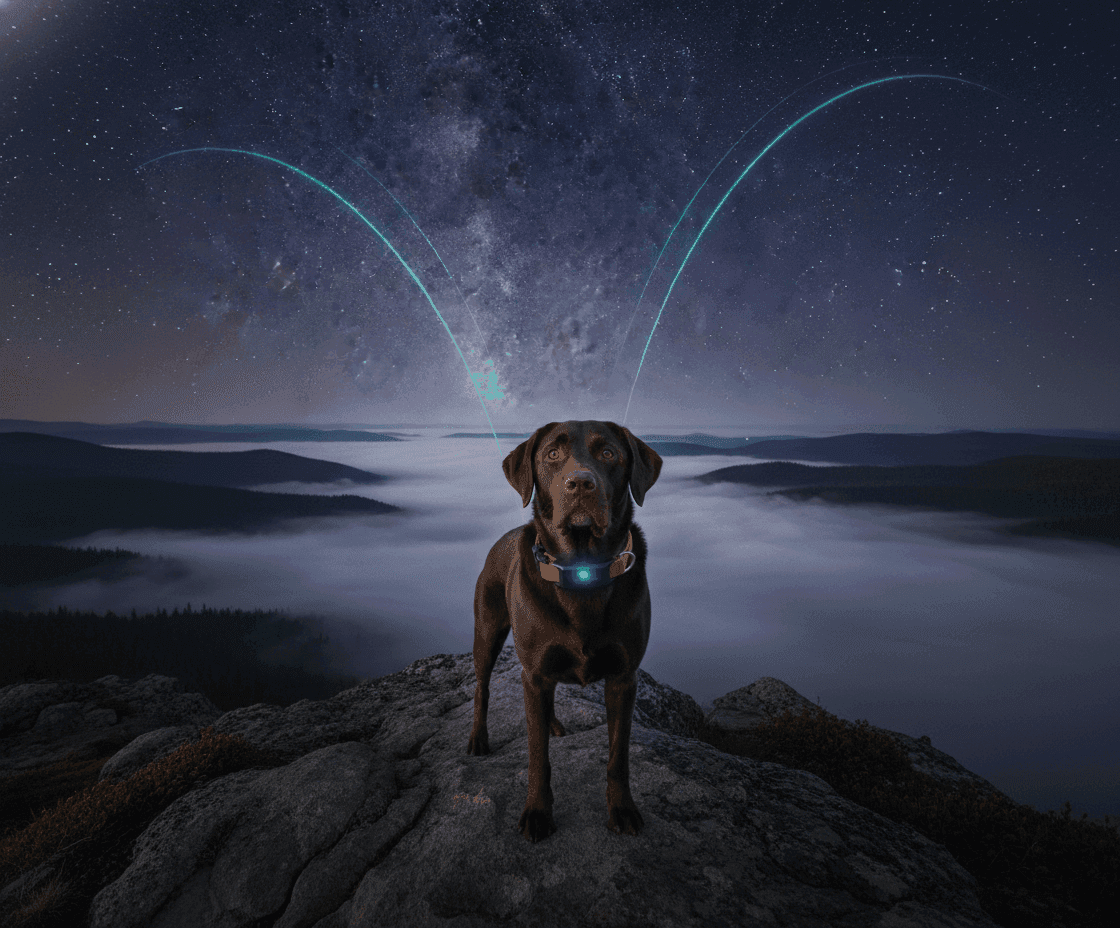
How Satellite Connectivity Changes Everything
GPS satellites already tell your dog's collar where it is. The missing piece has always been getting that information from the collar to you when there are no cell towers in range.
Satellite connectivity closes that gap by giving the collar a direct uplink to satellites orbiting overhead. No towers needed. No Wi-Fi needed. No crowd-sourced Bluetooth network needed. Just the collar, the sky, and a satellite constellation that covers the entire planet.
This is not science fiction. The 3GPP, the international body that sets global telecommunications standards, ratified Non-Terrestrial Network (NTN) specifications in Release 17, enabling small IoT devices to communicate directly with Low Earth Orbit (LEO) satellites using the same NB-IoT protocols that power cellular connections. This means satellite connectivity can be built into devices as small as a dog collar, without the bulky antennas and high power draw of traditional satellite communicators.
At PawPulse, we engineered this from the ground up. Our hybrid connectivity system uses a smart priority architecture:
When cellular is available (cities, suburbs, most highways), the collar transmits via LTE-M. It is fast, power-efficient, and provides real-time location updates.
When cellular drops (trails, farms, wilderness, dead zones), the collar automatically switches to LEO satellite transmission. It beams your dog's GPS coordinates directly to a satellite overhead, which relays them to our cloud, which pushes them to your phone.
There is no manual switch. No settings to change. No "satellite mode" to activate in a panic. The system detects the loss of cellular signal and handles the transition on its own. If your dog breaches a geofence or goes missing in an area with zero cell coverage, the satellite link activates automatically.
Your dog does not stop being trackable just because the coverage map ends.
The Battery Problem Nobody Talks About
There is a reason most GPS collars have not added satellite connectivity: power.
Transmitting to a satellite 600 kilometers overhead takes significantly more energy than pinging a cell tower a few miles away. A naive implementation would drain the battery in days, defeating the purpose of a device you are supposed to leave on your dog and forget about.
This is an engineering problem, and we obsessed over it.
PawPulse's satellite transmission system uses several power optimization strategies:
Antenna orientation gating. The collar checks whether its antenna has a clear path to the sky before attempting transmission. If the dog is lying on its side or under a roof, the system waits rather than wasting power on a transmission that would fail.
Burst mode. Instead of transmitting every location fix individually, the collar queues messages and sends them in a single burst during optimal satellite passes. This dramatically reduces the per-message power cost.
Adaptive GPS sampling. The collar adjusts how frequently it acquires GPS fixes based on context. A dog sleeping in the living room does not need a position update every 30 seconds. A dog that just breached a geofence does. Our system scales from 2-minute intervals when the dog is far from any boundary to 10-second intervals when precision matters.
Smart priority routing. Satellite transmission draws roughly 7 times more power than cellular. So the collar always prefers cellular when available and only uses satellite as a true fallback. This means in daily urban use, the satellite system costs zero battery. It is only active when it is genuinely needed.
The result: a target battery life of 30+ days with all sensors active, including GPS, health monitoring, and satellite backup. That is quarterly charging instead of weekly. A device that stays on your dog through every season, every hike, and every adventure.
Compare that to most cellular GPS collars that need charging every 3 to 7 days and lose their entire purpose the moment you forget.
More Than GPS: What Happens After You Find Them
Here is something worth considering: finding your dog is only half the problem.
A dog that bolted from a trail and spent two hours running through rough terrain may have injuries you cannot see. Elevated heart rate from exertion or panic. A paw injury masked by adrenaline. Heat stress from running in warm weather. Dehydration.
Most GPS collars can tell you where your dog is. They cannot tell you how your dog is.
PawPulse tracks 32+ health signals continuously through our multi-sensor health platform, including heart rate, heart rate variability, respiratory rate, activity patterns, sleep quality, and breath context, all read through fur using advanced radar sensing that requires no skin contact.
When you recover your dog after a scare, you do not just get a location pin. You get a full picture: "Heart rate peaked at 190 BPM during the chase. Currently 95 BPM and declining. Respiratory rate elevated but normalizing. No temperature spike detected. Gait appears normal."
That information, combined with the data shared through our Veterinary Dashboard, can help you and your vet determine whether a follow-up visit is needed or whether your dog is genuinely fine.
As we discussed in our post about how AI detects hidden signs of pain, dogs are masters at hiding discomfort. After a stressful event like getting lost, continuous monitoring catches what a visual once-over cannot.
Geofencing That Actually Protects
GPS tracking is reactive. Your dog is already gone, and you are trying to find them. Geofencing is proactive. It alerts you before the situation becomes an emergency.
PawPulse's geofencing system goes beyond basic circular boundaries:
-
Multi-radius progressive zones. Set Safe, Warning, Danger, and Emergency tiers around any location. You get increasingly urgent alerts as your dog moves further from the boundary, not just a single "your dog left the yard" notification after it is already too late.
-
Dynamic owner-anchored zones. On a hike, the safe zone moves with you. If your dog ranges too far from your position, you are alerted immediately, even if you are miles from any saved geofence.
-
Health-aware alerts. If your dog crosses a boundary while showing elevated stress indicators, the alert is flagged as higher urgency. A calm dog exploring the edge of the yard is different from an anxious dog bolting during a thunderstorm.
-
Satellite-ready boundaries. The stronger design is a collar that can use satellite backup when cellular is unavailable, so a geofence around your campsite is not dependent on the same network assumptions as a suburban backyard.
This is the difference between a virtual fence built only for your neighborhood and one designed for harder outdoor coverage zones.

The Industry Is Catching Up, But Slowly
The pet tech industry is beginning to recognize the satellite gap. At CES 2026, several companies discussed future connectivity enhancements. But as we analyzed in our CES 2026 smart collar comparison, most are still shipping cellular-only devices with satellite on a distant roadmap.
The challenge is that satellite connectivity is not a feature you bolt onto an existing product. It requires a fundamentally different hardware architecture, power management system, antenna design, and firmware stack. Companies that designed around cellular-only are facing a significant re-engineering effort.
PawPulse was designed from day one with hybrid connectivity as a core requirement, not an afterthought. The Lucero radio stack is planned around LTE-M, NB-IoT, and NTN satellite-ready backup in a single architecture. Final service availability depends on launch carrier support, roaming, certification, and configuration.
That architectural decision, made before a single unit shipped, is the difference between a product designed for harder coverage zones and one that treats them as a future bolt-on.
The Complete Picture
Think back to that trail in the Appalachian foothills. Your dog just chased a deer over a ridge and disappeared into dense forest. Your phone has no signal. Most GPS collars are silent.
With PawPulse, the story goes differently.
The collar detects the sudden sprint and geofence breach simultaneously. It attempts cellular transmission. No tower in range. In a satellite-supported launch configuration, the collar can use the backup path to move the alert when cellular is unavailable.
You pull up the map. You see her position updating. She is slowing down. The health overlay shows her heart rate dropping from 180 BPM to 120 BPM. She is stopping.
You follow the pin. Twelve minutes later, you find her at a creek, panting happily, completely unaware of the panic she caused.
The goal is not another collar that assumes Wi-Fi or a nearby tower. The goal is a collar designed with a backup path for the places ordinary trackers struggle.
The leash between you and your dog should not depend on the easiest coverage scenario.
That is what we are building.
Cellular-Only vs. Hybrid Cellular + Satellite at a Glance
| Capability | Cellular-Only GPS Collar | PawPulse (Hybrid) |
|---|---|---|
| Works in cities and suburbs | Yes | Yes |
| Designed for national forests / wilderness | No | Yes, via satellite-ready backup |
| Designed for rural properties beyond towers | No | Yes |
| Geofence alerts off-grid | Queued, delivered when back in range | Delivered over satellite |
| Live location while dog is running | Only with cell signal | Cellular when available; satellite on each pass |
| Requires extra hardware / separate app | No | No - integrated in one collar, one app |
| Battery life with GPS + connectivity active | 3-7 days | 30+ days |
| Health data continuity in dead zones | Buffered, delayed | Live heart rate / respiration over satellite |
| Wi-Fi or Bluetooth-network fallback | Near-useless in rural areas | N/A (satellite fallback instead) |
Want a dog collar built for tougher coverage zones? Explore our hybrid connectivity technology, learn how Pulse Therapy treats anxiety that can trigger bolting behavior, or see how veterinarians use PawPulse data to provide better care. Read more about how AI detects your dog's pain and how we are building beyond what CES 2026 showcased.
Frequently Asked Questions
Do GPS dog collars work without cell service? The GPS chip inside the collar can calculate your dog's position without cell service because GPS uses its own network of dedicated satellites. The problem is transmitting that position to your phone: every cellular-only collar needs a nearby cell tower to do that. No tower, no transmission. Satellite-enabled collars solve this by beaming the location directly to LEO satellites overhead.
How much of the U.S. has no cellular coverage? FCC-sourced data shows that roughly 30% of U.S. land area, about 870,000 square miles, has no reliable cellular signal. Globally, 3GPP estimates that 85% of Earth's surface lacks terrestrial cellular infrastructure. National forests, state parks, hunting grounds, and most rural properties beyond a few miles from highways fall inside that gap.
What is NTN and how does it relate to dog collars? NTN (Non-Terrestrial Networks) is the 3GPP standard that lets small IoT devices talk directly to Low Earth Orbit satellites using the same NB-IoT protocols as cellular. Because it's a mass-market standard, satellite support can be integrated into a single collar-sized modem rather than requiring a separate satellite communicator.
How often does satellite update my dog's location? LEO satellites pass overhead every 15-90 minutes depending on the constellation and your latitude. On each pass, the collar transmits queued location fixes and alerts. For comparison, a zero-signal cellular collar gives you no updates at all until it regains coverage, which can be hours or days later.
Does satellite backup drain the battery much faster than cellular? Satellite messages draw more power per transmission than cellular, but well-engineered collars compensate with burst-mode queuing, antenna-orientation gating, and adaptive GPS sampling. PawPulse targets 30+ days of battery life across both cellular and satellite operation, compared to 3-7 days for most cellular-only collars.
Is satellite dog tracking expensive? Traditional satellite communicators cost $400-800 plus a $30-60 monthly subscription. Collar-integrated satellite, built on 3GPP NTN standards, is a fraction of that because it uses mass-market chipsets rather than proprietary satellite hardware. One device, one subscription.
Will a satellite-enabled collar work internationally? Potentially, but it should not be treated as automatic. NTN satellite service depends on carrier support, roaming agreements, local certification, and the final launch configuration for the collar.
Can I use a standalone satellite communicator with my existing GPS collar? You can, but it means two devices, two subscriptions, two batteries to charge, and no automatic failover. If cellular drops, you have to manually pair and operate the satellite device. An integrated collar handles the handoff transparently, which is what matters the moment your dog bolts.
Learn more about PawPulse Lucero, the smart dog collar with cellular plus satellite-ready backup, so the moment your dog bolts is the moment you still know where they are.
Related reading: the lost-dog statistics that reframe collar safety and why location-only smart collars fall short.
-- The PawPulse Team